
Terraprobe Utility Location Services Data Sheet
Company Profile
Terraprobe Geocience Corp. is a market leader in GPR concrete scanning and utility location and mapping services. A team of highly trained technicians and geoscientists utilizing a large GPR equipment pools guarantees you unparalleled accessibility, reliability, and accuracy. Terraprobe: The GPR company that delivers!
Service Description
Over 30 years experience in Utility Locating
All job sizes from borehole clearing and single pipe locating to large scale mapping.
Best Practices and Reporting using American Society of Civil Engineers and CCGA Standards
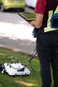
We always utilize both Ground Penetrating Radar (GPR) and Electromagnetic technologies
Deliverables:
Local Markings (paint flags etc.)
Hand Sketch of Located Utilities
AutoCad updated drawings (client provides base drawing)
We can locate BOTH metallic and Non-Metallic structures.
Locate targets up to 5 meter depth.
Practical and efficient in confined spaces and open terrain
One Call tickets procured by Terraprobe when requested.
Utility Location and Mapping
For Engineering Firms, General Contractors, Excavators and others that need to have utilities and other underground structures accurately located, Terraprobe can locate critical subsurface structures in a variety of materials - from construction sites to wide open terrain.
Unlike many locate companies that employ only Electromagnetic (EM) equipment, Terraprobe uses the latest and most advanced geophysical equipment required for the application. Terraprobe’s highly trained technicians can quickly and accurately determine the precise position of both metallic and non-metallic targets plastic and clay pipes, water, sewer and irrigation lines, cables, voids, and other subsurface features up to a depth of 5 meters or more. While the detectability of targets depends on a variety of conditions such as size, shape, and orientation of the target, subsurface material type and condition, as well as external radio frequency noise and interferences, Terraprobe has achieved an industry-leading 99% accuracy rate in finding its targets.
Utility location information is used to prevent damage to utilities in proposed excavation/drilling areas as well as for planning purposes by Utility companies, Municipalities, General Contractors and Engineering firms.
Our service provides results in real-time and covers large areas quickly and cost effectively, with reporting requirements tailored to meet the needs of the client.
Terraprobe follows the methodology as prescribed in CVASCE 38-02 “Standard Guideline for the Collection and Depiction of Existing Subsurface Utility Data” produced by the American Society of Civil Engineers.
Contact us for a free consultation and estimate on your next project
Or for faster response, give us a call at 604-553-4778