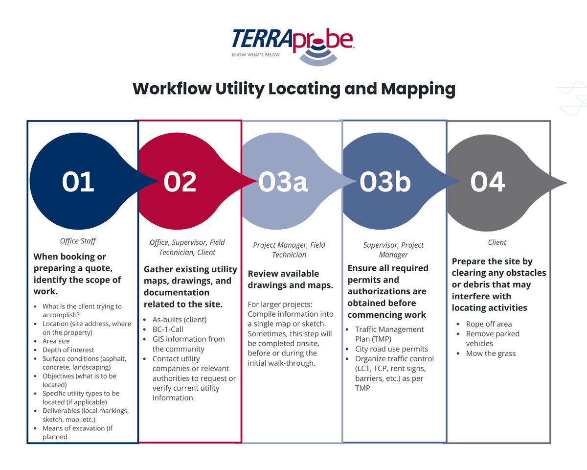
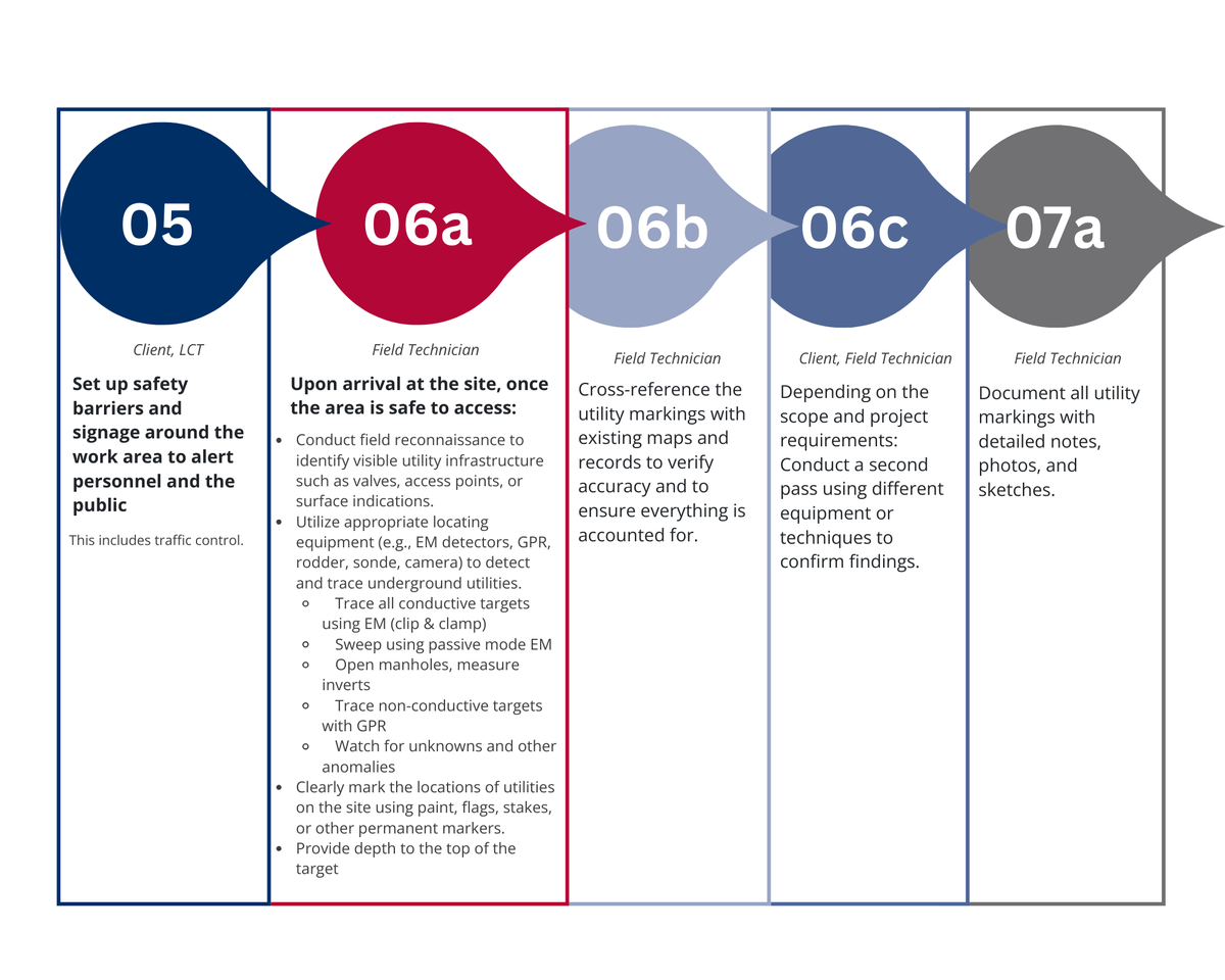
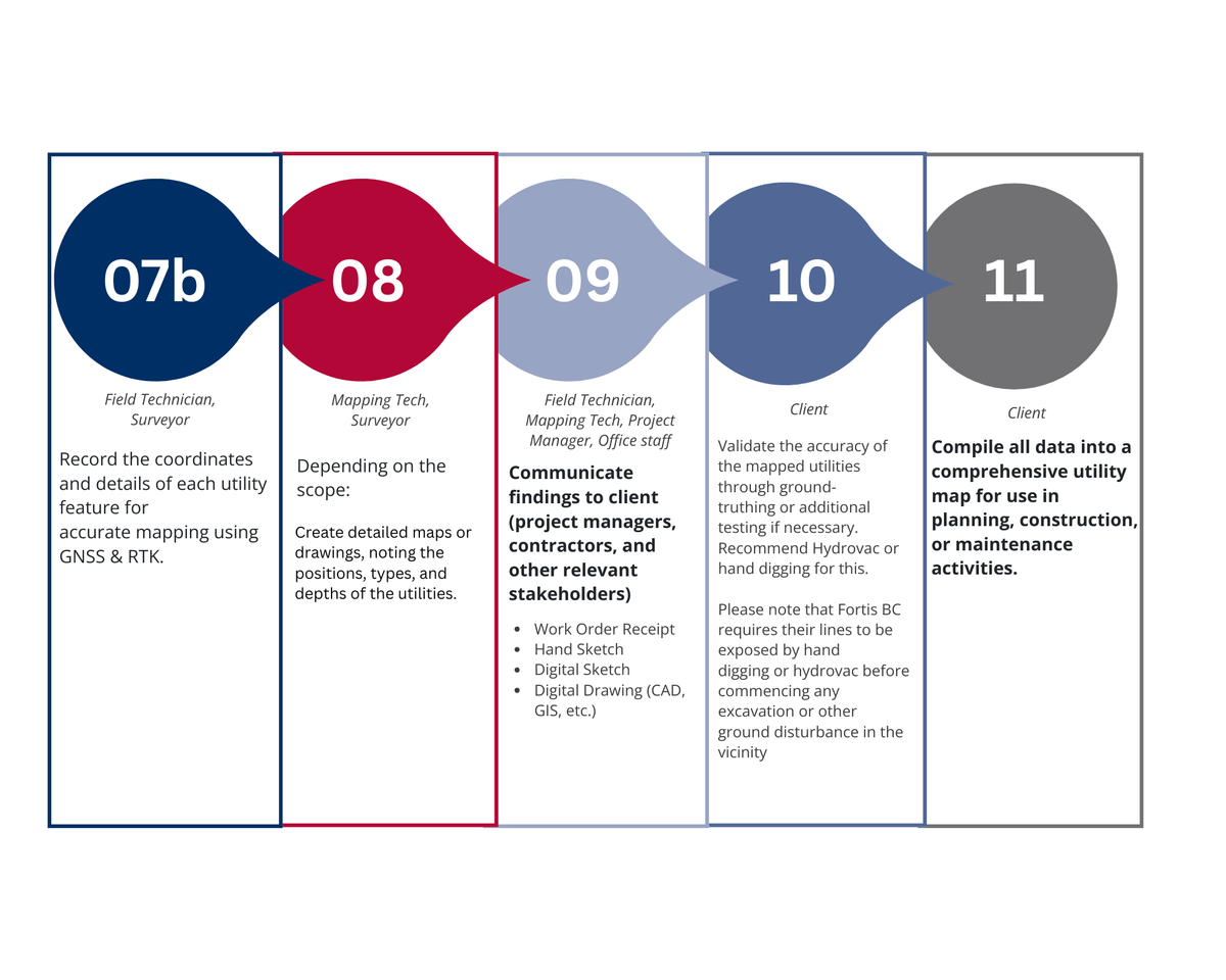
Workflow Utility Locating and Mapping

1. When booking or preparing a quote, identify the scope of work.

  • What is the client trying to accomplish?
  • Location (site address, where on the property)
  • Area size
  • Depth of interest
  • Surface conditions (asphalt, concrete, landscaping)
  • Objectives (what is to be located)
  • Specific utility types to be located (if applicable)
  • Deliverables (local markings, sketch, map, etc.)
  • Means of excavation (if planned)

Done by: Office Staff

2.Gather existing utility maps, drawings, and documentation related to the site

  • As-builts (client)
  • BC-1-Call
  • GIS information from the community
  • Contact utility companies or relevant authorities to request or verify current utility information.

Done by Office, Supervisor, Field Technician, Client

3a. Review available drawings and maps.

For larger projects: Compile information into a single map or sketch. Sometimes, this step will be completed onsite, before or during the initial walk-through.

Done by Project Manager, Field Technician

3b. Ensure all required permits and authorizations are obtained before commencing work

  • Traffic Management Plan (TMP)
  • City road use permits
  • Organize traffic control (LCT, TCP, rent signs, barriers, etc.) as per TMP

Done by Supervisor, Project Manager

4. Prepare the site by clearing any obstacles or debris that may interfere with locating activities

  • Rope off area
  • Remove parked vehicles
  • Mow the grass

Done by Client

5. Set up safety barriers and signage around the work area to alert personnel and the public.

This includes traffic control.

Done by Client, LCT

6a. Upon arrival at the site, once the area is safe to access:

  • Conduct field reconnaissance to identify visible utility infrastructure such as valves, access points, or surface indications.
  • Utilize appropriate locating equipment (e.g., EM detectors, GPR, rodder, sonde, camera) to detect and trace underground utilities.

- Trace all conductive targets using EM (clip & clamp)

- Sweep using passive mode EM

- Open manholes, measure inverts

- Trace non-conductive targets with GPR

- Watch for unknowns and other anomalies

  • Clearly mark the locations of utilities on the site using paint, flags, stakes, or other permanent markers.
  • Provide depth to the top of the target

Done by Field Technician

6b. Cross-reference the utility markings with existing maps and records to verify accuracy and to ensure everything is accounted for.

Done by Field Technician

6c. Depending on the scope and project requirements:

Conduct a second pass using different equipment or techniques to confirm findings.

Done by Client, Field Technician

7a. Document all utility markings with detailed notes, photos, and sketches.

Done by Field Technician

7b. Record the coordinates and details of each utility feature for accurate mapping using GNSS & RTK.

Done by Field Technician, Surveyor

8. Depending on the scope:

Create detailed maps or drawings, noting the positions, types, and depths of the utilities.

Done by Mapping Tech, Surveyor

9.Communicate findings to client (project managers, contractors, and other relevant stakeholders)

  • Work Order Receipt
  • Hand Sketch
  • Digital Sketch
  • Digital Drawing (CAD, GIS, etc.)

Done by Field Technician, Mapping Tech, Project Manager, Office staff

10. Validate the accuracy of the mapped utilities through ground- truthing or additional testing if necessary.

Recommend Hydrovac or hand digging for this.

Please note that Fortis BC requires their lines to be exposed by hand digging or hydrovac before commencing any excavation or other ground disturbance in the vicinity.

Done by Client

11. Compile all data into a comprehensive utility map for use in planning, construction, or maintenance activities.

Done by Client