Serving the Victoria British Columbia Area with GPR and Aerial Surveys
Discover the forefront of Ground Penetrating Radar (GPR) and aerial survey solutions with TerraProbe. Specializing in a wide array of services including aerial surveying, concrete scanning, utility locating and mapping, geotechnical and archeological surveying, roadway analysis, underground storage tank (UST) detection, and concrete cutting and coring, we are your go-to experts in the Victoria, British Columbia area.
Ground Penetrating Radar
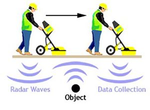
Terraprobe, established in 2001, is a leader in Ground Penetrating Radar (GPR) services for detecting objects within concrete, underground utilities, and other buried anomalies. With a vast inventory of advanced equipment and software, the company ensures precise, safe, and cost-effective GPR scanning. Terraprobe serves a wide range of clients, including general and specialized contractors, engineering firms, and property managers, making it the go-to GPR scanning provider in Western Canada.
Aerial Survey
Terraprobe provides comprehensive drone services customized to your requirements, serving Victoria and beyond from our Vancouver location. Whether you need support in planning or assessing construction sites, monitoring construction progress, or inspecting infrastructure with photogrammetry surveys, our skilled team employs advanced drone technology to deliver accurate and detailed results. These results can be used to review an entire site, the area surrounding it, and the progress being made in and around it. Aerial surveys are especially ideal for construction site managers to keep track of their teams progress.
Concrete Scanning
Terraprobe offers GPR concrete scanning services throughout Victoria and the surrounding area. Their services are designed to safely and accurately detect and map rebar, conduits, and post-tension cables within concrete structures, ensuring structural integrity and project safety.
Utility Location and Mapping
Whether you're seeking to pinpoint a solitary buried pipe or delineate an extensive network of underground structures spanning kilometers of roadway or acres of land, Terraprobe is your go-to solution provider in Victoria and the surrounding area. Our seasoned technicians, armed with top-tier equipment, ensure the successful execution of utility location projects, regardless of scale or complexity.
Geotechnical & Archeological Surveying
Terraprobe brings the formidable capabilities of Ground Penetrating Radar (GPR) to Victoria, offering unparalleled advantages in archaeological surveys. With its non-invasive capacity to penetrate the ground, GPR provides precise subsurface imaging, cementing its status as an essential tool for archaeological investigations in our region. Trust Terraprobe to unlock the secrets hidden beneath Victoria's soil.
Roadway Analysis Survey
Ground penetrating radar (GPR) is used as a tool for assessing the condition of the pavement at locations of distress, as well as identifying areas of previous maintenance/repair activities that are not visible. In assessing the existing condition of a pavement structure, locations of past maintenance activities are often overlooked, or concealed by rehabilitation activities such as mill and overlays. Potential problem areas may not be evident at the time of evaluation, and if ignored could increase the rate of deterioration of the pavement structure.
Contact us and ask what we can do to help your project here.

